*This post may contain affiliate links. If you make a purchase through one of these links, I may earn a small commission at no extra cost to you. Read my full disclaimer here.
There’s something magical about stepping off the beaten path and immersing yourself in raw, untouched wilderness. Off-trail hikes aren’t about well-marked paths or predictable Instagram views; they’re about adventure, solitude, and sometimes, pushing yourself to the limit.
If you’re craving a true sense of exploration and the chance to see things few others have, these three off-trail hikes should be at the top of your list. These are my personal favorites, and while they’re not for everyone, they’re unforgettable experiences for those ready to take on the challenge.
Safety First
Before we get into the hikes, let’s talk safety. Off-trail hiking is incredible, but it’s also risky if you’re not prepared. There’s no cell service in remote spots, so you need to rely on old-school tools like a compass or a GPS (and actually know how to use them).
Some safety essentials for off-trail hiking include:
- Download maps offline: Use apps like Gaia GPS or AllTrails, but always carry a printed map just in case.
- Plan ahead: Research the route thoroughly and understand the terrain. Trip reports from other hikers can be goldmines of information.
- Pack the essentials: Bring plenty of water, snacks, a first-aid kit, and layers. The weather can change fast in the wilderness.
- Carry a satellite communicator: Devices like a Garmin inReach can quite literally be lifesavers.
- Tell someone your plan: Share your route and expected return time with a trusted friend or family member.
With the safety talk out of the way, here are three hikes that will blow your mind:
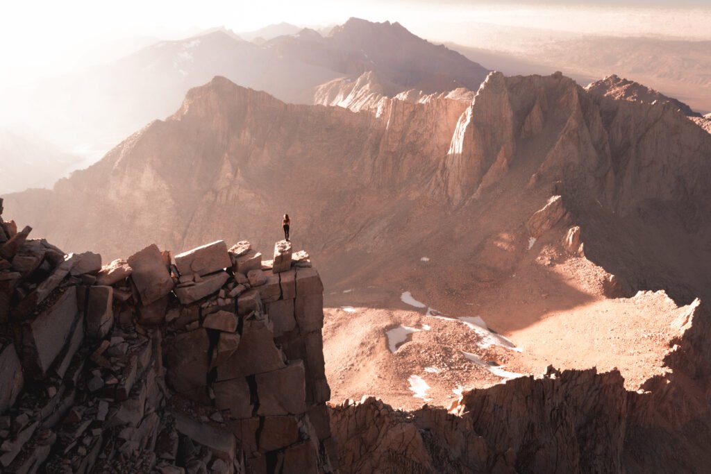
1. Mount Whitney Mountaineer’s Route

Location: California, near Lone Pine
Difficulty: Extremely challenging (this isn’t your average weekend hike)
Highlights: Stunning rock formations, breathtaking summit views, and a much quieter experience compared to the standard Mount Whitney Trail.
Permit Required: Yes, apply via Recreation.gov.
About the Mountaineer’s Route:
This hike is for the true adventurer seeking a challenge and a deep connection with the rugged wilderness. The Mountaineer’s Route up Mount Whitney is not your average hike—it’s a test of skill, endurance, and determination that rewards you with unmatched solitude and breathtaking scenery. Unlike the well-trodden and often overcrowded main Mount Whitney Trail, this off-trail route offers a quieter, more intimate experience with the mountain. It’s steep, technical in places, and requires GPS navigation to stay on track. Designed for experienced hikers with mountaineering skills, this route is perfect for those who crave a journey that’s as thrilling as it is demanding.
Starting near Whitney Portal, the hike begins with a steep ascent through a forested trail. Early on, you’ll be greeted by the sound of Lone Pine Creek rushing alongside the path, offering a refreshing ambiance. As you climb higher, the terrain transitions into rocky slopes, granite boulder fields, and scree-covered areas. The route is unmarked in many sections, requiring navigation skills and precise attention to detail.
The climb up the Ebersbacher Ledges requires careful footing but rewards you with amazing views. From there, you’ll reach Lower Boy Scout Lake, a peaceful alpine lake surrounded by jagged peaks—an ideal spot to rest. Higher up is Upper Boy Scout Lake, another stunning stop, before tackling the steep slopes to Iceberg Lake. Nestled beneath the final ascent, Iceberg Lake is a breathtaking destination with icy waters and dramatic mountain scenery, perfect for a pause or an overnight camp.
The last section of the route is where the real mountaineering begins. The terrain becomes increasingly demanding as you scramble up steep granite slopes and navigate the notorious chute—a challenging and exhilarating climb that requires focus, strong footing, and a willingness to push through physical and mental barriers. The air thins as you gain altitude, and the effort intensifies, but the sense of accomplishment grows with every step.
Standing on top of Mount Whitney, the tallest peak in the contiguous United States at 14,505 feet, is an experience like no other. Whether you catch the sunrise or sunset, the views are nothing short of spectacular. The light casts a golden hue over the Sierra Nevada, highlighting the rugged peaks and sprawling landscape. It’s a moment that offers a true appreciation of the vast beauty surrounding you.
The Mountaineer’s Route is not for the faint of heart. This trail demands preparation, fitness, and mountaineering experience. Proper gear, including crampons and an ice axe during certain seasons, is essential for safety. But for those who are ready to take on the challenge, this hike is a life-changing adventure—a chance to push your limits, reconnect with nature, and stand atop one of the most iconic summits in the United States. It’s exhilarating, exhausting, and absolutely worth every ounce of effort.
Nearby Camping and Lodging
Camping: The Whitney Portal Campground is a great base camp (reserve on Recreation.gov). For free camping, explore the scenic Alabama Hills nearby.
Lodging: Check out Lone Pine’s cozy motels for a good night’s sleep before and after the hike (find options on Booking.com).
2. The Subway, Zion National Park

Location: Zion National Park, Utah
Difficulty: Moderate to hard (requires swimming, scrambling, and rappelling)
Highlights: Jaw-dropping slot canyons, sculpted rock formations, and emerald pools.
Permit Required: Yes, through Zion’s lottery system on Recreation.gov.
About The Subway:
If you’ve seen photos of The Subway in Zion National Park, you already know it’s an otherworldly wonder—a stunning combination of narrowing canyons, swirling red and orange sandstone, and clear pools of blue and emerald water. But seeing it in person? It’s an unforgettable experience that leaves you in awe of what nature can create. This incredible slot canyon, carved over millions of years by the Left Fork of North Creek, is one of Zion’s most famous and unique hikes. It gets its name from the smooth, tubular section of the canyon that resembles a subway tunnel.
The Subway was formed through millions of years of water erosion, as the Left Fork of North Creek flowed persistently through the sandstone. The rushing water smoothed and carved the rock into its iconic curves, creating the tubular canyon walls that make The Subway so distinctive. Over time, seasonal flows and flash floods further shaped the canyon, polishing the stone and leaving behind the crystal-clear pools that enhance its surreal beauty.
A Quick Overview of The Subway Hikes:
The Subway offers two distinct hiking experiences: the Bottom-Up Route and the Top-Down Route. Both are challenging and rewarding in their own ways, showcasing the beauty and raw power of nature while giving hikers a chance to connect with Zion’s rugged landscape. The two ways to hike The Subway cater to different skill levels, interests, and outdoor goals. Here’s everything you need to know about these two routes, along with tips, highlights, and historical context to make your adventure to The Subway even more meaningful.
Bottom-Up Route
Difficulty: Moderate to strenuous, but no technical gear is required.
Distance: Approximately 9 miles round-trip.
Time: 6-10 hours, depending on your pace and photography stops.
What to Expect:
Starting from the Left Fork Trailhead, the Bottom-Up Route takes you on an adventurous journey through the rugged beauty of the canyon. This off-trail hike involves traversing the riverbed, scrambling over boulders, and wading through shallow water to reach the iconic Subway section. While it doesn’t require technical skills like rappelling, the hike is physically demanding, with uneven terrain and a constant need to navigate rocks and water. Finding your way can be tricky, as the route lacks clear signage, so it’s crucial to know key markers along the way and have a GPS device handy. The hike rewards your effort with stunning sights, including cascading waterfalls, small pools, and the gradual narrowing of sandstone walls as you approach The Subway.
Highlights: The iconic Subway tunnel, vibrant pools, waterfalls, and the chance to take your time capturing photos of the unique geology.
Best For: Hikers who are newer to off-trail adventures, those who prefer a less technical challenge, or anyone looking to focus on photography and soaking in the scenery.
Top-Down Route
Difficulty: Very strenuous, with technical canyoneering required.
Distance: About 9.5 miles one-way.
Time: 8-12 hours, depending on experience and conditions.
What to Expect:
This route begins at the Wildcat Canyon Trailhead and is only suitable for experienced canyoneers. It requires a high level of fitness, technical skills, and proper gear, including ropes, a harness, a wetsuit or dry suit for the frigid water, a helmet, and waterproof bags for your belongings. The hike involves rappelling down waterfalls, wading through deep pools, and swimming through cold water, often in challenging and rugged terrain. It is considered an off-trail route, so a reliable GPS device and detailed maps are essential for navigation through the canyon’s narrowest and most dramatic sections. Permits may also be required, so ensure you check regulations and prepare accordingly. This is a highly immersive and adventurous experience, and thorough preparation is a must for safety.
Highlights: Thrilling rappels, natural water slides, deep emerald pools, and remote sections of the canyon that few hikers get to see.
Best For: Experienced adventurers who are comfortable with technical canyoneering and willing to take on a physically demanding day.
Nearby Camping and Lodging
Camping: Stay at Watchman Campground or South Campground (both bookable through Recreation.gov).
Lodging: Springdale, right outside the park entrance, has some fantastic boutique hotels and cozy stays. You can find options on Booking.com.
3. Magic Grove of Bristlecone Pines, Mount Washington

Location: Great Basin National Park, Nevada
Difficulty: Moderate
Highlights: A grove of the oldest living trees in the world, panoramic mountain views, and complete solitude.
Permit: None required
About the Magic Grove of Bristlecone Pines:
Bristlecone Pines are among the oldest living organisms on Earth, with some dating back over 4,000 years. The grove on Mount Washington, often called “The Magic Grove,” is home to some of these ancient trees. The trees here have adapted to the harsh environment, twisting into striking shapes with gnarled branches that seem to defy time. Standing among them is a reminder of nature’s resilience. At this altitude, the views stretch endlessly, offering a unique sense of peace and perspective.
The hike to The Magic Grove is a challenging 13-mile roundtrip adventure with a 3,200-foot elevation gain, reaching 11,000 feet at the grove. While not as technical as trails like Mount Whitney’s Mountaineer’s Route, it requires preparation and resilience. The trail is poorly marked and often nonexistent, requiring a GPS, compass, and thorough preparation to navigate the rugged terrain..
Sturdy hiking boots are a must for the rocky, uneven ground, and the ever-changing weather at this altitude requires layers to stay comfortable. Frequent breaks and proper hydration are essential to manage the elevation and steep ascent.
The Magic Grove, at 11,000 feet, feels like another world. Surrounded by ancient bristlecone pines, their twisted trunks shaped by centuries of wind and weather, the space is vast and quiet. The air is thin, cool, and carries the sharp scent of pine. There’s a stillness here that’s hard to find anywhere else—just the sound of the wind through the branches and the occasional bird call. With no other people in sight, the solitude is absolute, as if time moves slowly in this untouched place. The grove is a stark, beautiful reminder of nature’s resilience in this harsh, exposed environment.
Nearby Camping and Lodging
Camping: Primitive camping is available within Great Basin National Park, as well as campgrounds. Permits and reservations are required and can be purchased on Recreation.gov.
Lodging: The quiet town of Baker has a few lodging options that make for an excellent post-hike stay. Check availability on Booking.com.
Explore Off-Trail Responsibly
For adventurous hikers, these off-trail experiences are bucket-list worthy. Each one offers the chance to connect with nature in a way you simply can’t on more crowded trails. But that privilege comes with responsibility. Always respect Leave No Trace principles to protect these wild places.
When you’re ready to tackle these hikes, just remember to obtain the necessary permits from Recreation.gov and plan your accommodations through Booking.com. Trust me, a warm bed (or a peaceful campsite) feels amazing after a challenging hike.
Have you done any of these hikes or have others to recommend? I’d love to hear your stories in the comments. Happy hiking, and stay safe out there!